Pullman, WA to Snoqualmie Summit, Wa
After attending Sasquan, the World Science Fiction Society convention in Spokane, Washington, we took a trip 75 miles south to Pullman, Washington, home of Washington State University. Along the way, we admired the huge rolling hills of the Palouse region, and such natural wonders as Steptoe Butte (named for a US Army officer who lost a battle to the Palouse tribe) and Kamiak Butte (named after Chief Kamiakin, a Yakima and Palouse leader that faced off against the US Army). Due to extremely heavy smoke from forest fires in British Columbia, Idaho, and Washington, we couldn’t see any of the natural wonders. It was mostly an imaginary admiration.
A few days later, we drove from Pullman to Bremerton, Washington. Pullman is next to the Idaho border, and Bremerton is 350 miles away. Decades earlier, before roads were widened, straightened, added, bridged, etc., the trip was almost 400 miles, one way, with most of that trip through — nothing.
The navigator for the journey was not familiar with the route, but given an iPad and Google Maps, she was prepared for the intricate navigational challenges. The first step, drive north from Pullman 14 miles to Colefax, WA, then turn left on Washington 26 for 137 miles to Vantage, Washington, on the banks of the Columbia River. Between Colefax and Vantage, there is — nothing.

During this first leg of 151 miles, from Pullman to Vantage, we saw fewer than a dozen vehicles on the road. That includes passing through Colefax, the seat of Whitman County. We did see the occasional farm building, power line, or highway sign, but even those were few and far, far between. A screenshot of Google Maps reveals nothing, which is revealing.

After about an hour, as we crested one hill only to see miles of more of the same, the navigator started giggling. Several minutes later, at the crest of the next hill (these are big hills, and even at 65 mph it takes a while to get from one crest to the next), she burst out laughing. We stopped in Washtucna, mostly because we’d never stopped in Washtucna in perhaps a hundred trips down this highway. We saw one person at the combination gas station, convenience store, museum, and thrift shop.
Between the yellow-tinged sky (due to smoke) and the miles and miles of little more than sagebrush and tumbleweeds, the mind is starved for green. Due to the severe drought, even the small rivers and irrigation ditches were dry, and everything was brown.
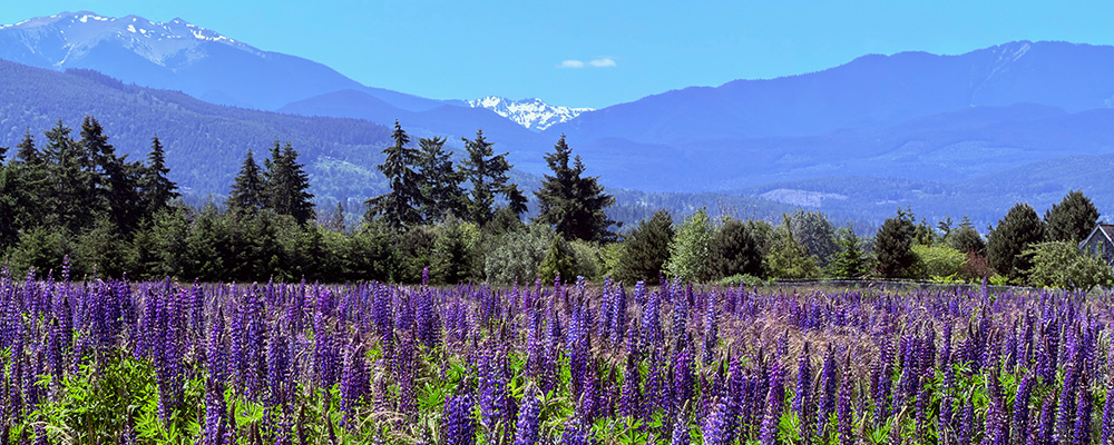
Eventually, we came to the broad, blue waters of the Columbia River. A couple of hours later, we crested the Cascade Mountains at Snoqualmie Pass, and dove into western Washington’s riot of evergreens. Even in the middle of a spectacular drought, western Washington fairly glowed with green.

For those interested in seeing more photos of the Empty Quarter, we’ve created a photo catalog of the Pullman to Snoqualmie trip.
And if you wondered, yes, I do love eastern Washington. The vast emptiness has a stark beauty and intense grandeur. Though green is in short supply.